Nature Trails
Hiking between "contrade"
1. "Sanco - Contrada Roncari - Contrada Gaiga "
Route length: 6.4 km – Duration: 2 hours - Distance from B&B: 0km
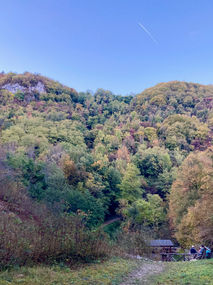
This itinerary starts directly from the house and leads to the nearby "contrada" Roncari. It then continues through the woods, offering glimpses of Durlo and the Tre Croci mountain range. The trail joins the Orco path until it reaches the "contrada" Gaiga. From there, you can either continue along the Water Trail to Durlo or return toward Sanco, as suggested in this route.
2. Sanco – Bolca - Pesciara (Fossile Cave)
Distance: 7.1 km – Duration: 2 hours - Distance from B&B: 0km
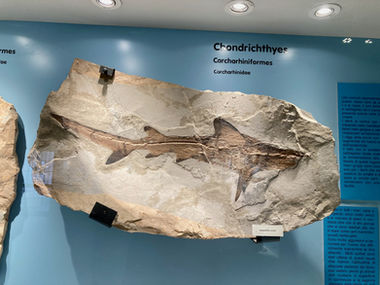
This route runs entirely through exceptional natural sites. Starting from the B&B Il Sanco, it follows comfortable mule tracks to reach the area of Bolca, internationally renowned for its fossil deposits and widespread volcanic rock formations. The trail passes near the Purga di Bolca, the Fossil Museum of Bolca, Monte Postale, and ends at La Pesciara, the main fossil excavation site. Route link.
3. Badia Calavena – Bolca
Distance: 6.7 km – Duration: 2 hours - Distance from B&B: 7.7km
Starting near the Benedictine Cloister in Badia Calavena, the trail leads past the ancient monastery and Church of St. Peter, continuing north through several traditional eastern Lessinia hamlets. From Venchi, one can head toward Bolca or San Bartolomeo delle Montagne.
4. Bolca – Purga – Pesciara
Distance: 3.5 km – Duration: 1 hour 30 min - Distance from B&B: 5.8km
From the village of Bolca, the trail ascends Monte Purga, descends to Contrada Loschi, then continues via Contrada Brusaferri to the fossil site of La Pesciara.
5. Selva di Progno – Campofontana - Distance from B&B: 1.3km
Distance: 7 km – Duration: 2 hours
This scenic trail ascends Val d’Illasi, passing Anselmi, Frighi, Zucchi, San Giorgio, and ending in Campofontana.
6. Frighi – San Bartolomeo delle Montagne - Distance from B&B: 2.7km
Distance: 5 km – Duration: 1 hour 30 min
Connects Contrada Frighi to San Bartolomeo delle Montagne via Brea and Pernigotti along a wide mule track.
7. Parparo – Giazza
Distance: 5.5 km – Duration: 1 hour 30 min - Distance from B&B: 6.6km
An ancient transhumance path from Malga Parparo to Giazza, descending through forests along the E5 trail.
8. Campofontana – Le Giare
Distance: 16.5 km – Duration: 5 hours - Distance from B&B: 1.1km
A high-altitude trail crossing multiple malghe and ridges from Campofontana to Le Giare via Cima Lobbia.
9. Anselmi – Corno Barilla – Malga Lobbia
Distance: 5 km – Duration: 1 hour 30 min - Distance from B&B: 0.8km
From Anselmi through Mori and Vanti to Corno Barilla and high pastures of Malga Lobbia.
10. Anselmi – Sant’Andrea
Distance: 2 km – Duration: 40 min - Distance from B&B: 0.8km
Flat and panoramic, through Belvedere, Gonzeri, Cisamoli, Trettene, and ending in Sant’Andrea.
11. Boscangrobe – Selva di Progno
Distance: 4.8 km – Duration: 1 hour 30 min - Distance from B&B: 1.6km
From Boscangrobe past Zicoli, Bosco, Nouc, and other hamlets, ending in Selva di Progno.
12. Croce del Gallo – Parlatoni
Distance: 4.2 km – Duration: 1 hour 30 min - Distance from B&B: 1.6km
Passes Tecchie, Battister, Pozze; connects to other trails at Parlatoni.
13. Selva di Progno – Covolo di Camposilvano
Distance: 7.5 km – Duration: 2 hours - Distance from B&B: 1.3km
Follows an old trail through prehistoric sites and caves, ending at the Covolo and Geo-Paleontological Museum.
14. Velo Veronese – Monte Purga (round trip)
Distance: 1 km – Duration: 1 hour - Distance from B&B: 2.8km
Short climb to panoramic Monte Purga, former ancient fort location.
15. Covolo di Camposilvano – Croce di Parparo
Distance: 4 km – Duration: 1 hour 20 min - Distance from B&B: 5.1km
Passes Il Fungo, Valle delle Sfingi, and malghe, ending at Croce di Parparo.
16. Croce di Parparo – Covolo di Camposilvano
Distance: 3.4 km – Duration: 1 hour 30 min - Distance from B&B: 5.1km
A reverse ridge trail passing Casa Kuneck, ending in Camposilvano.
17. Podestaria – Erbezzo or Bosco Chiesanuova junction
Distance: 10 km (Erbezzo)– Duration: 3–3.5 hours - Distance from B&B: 12.6km
Trail through valleys and contrade, connecting to Erbezzo or Bosco Chiesanuova.
18. Erbezzo – Ponte di Veja
Distance: 7.6 km – Duration: 2 hours - Distance from B&B: 12.3km
Follows the E5 trail through hamlets and ends at the natural arch Ponte di Veja.
19. Ponte di Veja – Fosse (Sant’Anna d’Alfaedo)
Distance: 7 km – Duration: 2.5 hours - Distance from B&B: 10.6km
Scenic path through old contrade and chestnut woods to Fosse.
20. Podestaria – Castelberto Junction (Via Cordoni)
Distance: 4.9 km – Duration: 1 hour 30 min - Distance from B&B: 12.6km
High-altitude trail with views over the Carega range.
21. Castelberto Junction – Castelberto
Distance: 1.3 km – Duration: 30 min - Distance from B&B: 18.3km
Short extension to Cima Castelberto with spectacular views.
22. Castelberto Junction – Passo Fittanze – Cornetta
Distance: 6.6 km – Duration: 1 hour 45 min - Distance from B&B: 18.3km
Trail over pastures via Pozza Morta, Spluga del Martin, and Passo Fittanze to Monte Cornetta.
23. Cornetta – Fanta – Fosse
Distance: 9.5 km – Duration: 2.5 hours - Distance from B&B: 17.4km
Through Malga Fanta and Corno d’Aquilio, passing the Spluga della Preta and descending to Fosse.
24. Fosse – Peri – Spiazzi
Distance: 13.7 km – Duration: 4 hours - Distance from B&B: 16.4km
Links the Lessinia plateau to Mount Baldo via Peri and Madonna della Corona, ending in Spiazzi.
Paths and Trails

1. The Path of the Seven Volcanoes
https://www.camminodeisettevulcani.it/index.php
2. Short itineraries in Lessinia
https://verona.com/it/lessinia/itinerari-brevi/
3. Lessinia GPS (blog with tracks and maps)
https://lessiniagps.blogspot.com/
4. Eastern Lessinia and Malga Lobbia
https://www.altalessinia.com/percorso-trekking-lessinia-orientale-madonna-della-lobbia/
http://www.altalessinia.com/tracks/lobbia/
5. Durlo and the Fairy Forest
6. The Covoli of Velo and the upper Val d’Illasi
http://altalessinia.com/percorso-covoli-velo-veronese-alta-val-illasi/
http://altalessinia.com/tracks/covolivelo/
7. Various trails and routes
https://www.magicoveneto.it/lessini/
http://www.magicoveneto.it/lessini/trek.htm
https://verona.com/it/lessinia/itinerari-brevi/
8. Valle di Revolto
Distance: 10.2 km – Duration: 4 hours
Take bus no. 121 (or go by bike or car) to Giazza. Continue for about 2 km along Provincial Road no. 10 to the locality Le Giare (1100 m, with parking). From here, follow the European Trail E5 to the Orti Forestali (1217 m), then continue up the Valle di Revolto to Lago Secco. Cross to the opposite side of the valley and, after a short ascent, reach Rifugio Revolto (1336 m). From the hut, the trail ascends with rapid switchbacks to Bocca Trappola (1533 m) and then to Passo Malera (1722 m), providing access to the High Pastures of Lessinia. The trail descends to the Mandriello area (1350 m), then loops back to Le Giare.
9. Val Fraselle
Distance: 7 km – Duration: 2 hours
A scenic route within the Oriented Nature Reserve of the Lessinia Regional Park, following the forest road of Val Fraselle. Starting from the village of Giazza (759 m), the trail runs alongside the Fraselle stream for about 2 km, through mixed broadleaf and conifer forests, to reach Malga Fraselle di Sotto (1475 m). It then climbs steep grazing slopes to Malga Fraselle di Sopra (1630 m).
10. Croce di Parparo – Podestaria
Distance: 11.8 km – Duration: 3 hours
A very scenic route on an unpaved road closed to traffic, offering commanding views of the surrounding valleys and the plains with Lake Garda in the background. From Croce del Parparo (1392 m), head north across pastureland to reach Malga Parparo di Sopra (1442 m), then continue along the E5 trail and the ancient Lessinia road, still heading north. Near Malga Grola (1550 m), the trail descends, continuing toward S. Giorgio (a winter tourist resort). Heading northeast, pass Malga Gaibana on the right and reach Bocca Gaibana (1588 m), a panoramic viewpoint over the Carega group and the Val di Ronchi. Continue west to Pozza Morta (1715 m), then cross Dosso delle Gasparine Davanti to arrive at Malga Podestaria (1655 m), the historic summer residence of the Podestà.
11. Malga Malera di Sotto – S. Giorgio
Distance: 3.8 km – Duration: 1 hour
A short trail that winds through high-altitude pastures and alpine huts. From Malga Malera di Sotto (1561 m), head north along a mule track to reach Passo Malera (1722 m). From there, continue west into the Vallone del Malera, passing the striking karst depression known as Buco del Vallone, and descend to S. Giorgio.
12. Pozza Morta – Monte Sparvieri
Distance: 0.5 km – Duration: 30 minutes
A short itinerary entirely through alpine pastureland, leading from Pozza Morta (1517 m) to the summit of Monte Sparvieri (1727 m), a wide panoramic point overlooking the Carega mountain group and the Lessinia plateau.
13. Podestaria and the Vaji
Distance: 16.4 km – Duration: 5 hours
A long hike through some of the most characteristic and interesting landscapes of the plateau. The trail passes through broadleaf and conifer forests along several vaji (valley ravines), and open high-altitude pastures between 1450 m and 1650 m, where Monte Veronese cheese is still produced using traditional methods.
Starting from Podestaria (1655 m), head east, skirting Monte Tomba and descending into Vajo delle Ortighe and the enchanting Foresta dei Folignani. Continue through the vajo to reach the Arbi di Cornicello. Enter Vajo dell’Anguilla and turn right into Vajo dei Modi (1200 m), ascending for about 700 m to reach Fontana degli Alpini (1290 m).
At Malga Dosso del Pezzo, turn left toward Bocchetta della Vallina (1488 m), then head north along the municipal road to reach Bivio Malga Roccopiano (1530 m). From there, pass Malga Lessinia (1617 m) and return to Podestaria along the Cordoni ridge path.
This route connects with trail “n. 15” at Bivio Malga Roccopiano.


